About 250,000 people will start evacuating from Hampton Roads today ahead of Hurricane Florence. Virginia Governor Ralph Northam ordered the evacuation of people living in flood-prone “Zone A.” However, there has been some confusion from residents about which zone they live in and the Virginia Department of Emergency Management’s website experienced problems. Here’s a guide to Hampton Roads’ hurricane evacuation zones.
You can use the Virginia Hurricane Evacuation Zone Lookup tool to find out if your property is in Zone A.
As well as flood-prone parts of Hampton Roads, evacuations have been ordered on the Outer Banks of North Carolina in Dare and Currituck County. This is an extremely dangerous storm. Although the final path of the storm is not known, you should not stay put if you are in a mandatory evacuation zone.
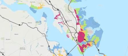
In Hampton Roads, Zone A, the blue zone on the maps, includes areas on the Nansemond River in Suffolk or its tributaries. It includes areas close to the river in Smithfield. In Portsmouth, it includes areas on the Elizabeth River, Olde Towne Portsmouth, Norfolk Naval Shipyard, the Naval Hospital, Cradock and Gilmerton.
In Chesapeake, the zone includes the areas along the intracoastal waterway. In Norfolk areas along the Lafayette River, downtown, Ghent, Willoughby Spit, Lambert’s Point, Lakewood, Tanglewood, and areas near the airport are being evacuated.
Many parts of Norfolk see serious flooding during heavy downpours not associated with storms. These areas are likely to see the most acute flooding. You should avoid driving in these areas.
Large swathes of southern Virginia Beach are in Zone A. They include Sandbridge and Pungo. Parts of northern Virginia Beach near First Landing State Park are in the zone. Lynnhaven Shores is one of the areas being evacuated.
Parts of the Virginia Peninsula are in Zone A including areas around Langley Air Force Base, Buckroe, downtown and Fort Monroe in Hampton. In Newport News, the zone includes large swathes of the southeast community and Greenwood. Low-lying Poquoson and Seaford are in zone A.
Extensive coastal areas on the Eastern Shore of Virginia both on the Atlantic and the Chesapeake Bay side are included in the Zone A evacuation area.
The hurricane was predicted to make landfall late Thursday. Models released today predict it is more likely to hit on Friday morning.
The hurricane center estimates rainfall associated with Florence will range from 15 to 20 inches across North Carolina, northern South Carolina and Virginia. Some isolated areas could even get 30 inches, weather forecasters predict.
Where to Evacuate from Hampton Roads
Head north and west. Tolling has been suspended on the Route 168 Chesapeake Expressway as people head north from the Outer Banks to escape the hurricane. You should be aware that some parts of inland Virginia close to North Carolina and the mountains may see catastrophic rainfall from this storm days later.
The governor has the ability to reverse I-64 so as no traffic can head into Hampton Roads but more capacity increases for motorists traveling out of the region.
No indication the roads will be reversed has been given yet.
Here are the designated evacuation routes for Hampton Roads and the Eastern Shore of Virginia.
Hampton Roads Hurricane Evacuation from the Virginia Peninsula
- Interstate 64 West
- Interstate 664 North
- S. Route 17 North
- S. Route 60 West
- Route 143
The Jamestown-Scotland Ferry will be removed from service and is not part of the evacuation plan.
Hampton Roads Hurricane Evacuation from the Southside
- Interstate 64 Hampton Roads Bridge-Tunnel and 264 West;
- Interstate 664 North Monitor Merrimac Memorial Bridge-Tunnel
- S. Route 17 North
- S. Route 58 West
- S. Route 460 West
- Route 10 West
The Chesapeake Bay Bridge-Tunnel is not an evacuation route and may be closed during severe storms.
Hurricane Evacuation from the Eastern Shore of Virginia
All Eastern Shore residents must use U.S. Route 13 North in the direction of Salisbury, Maryland.
What You Need for a Hampton Roads Hurricane
The following is a list of emergency supplies and equipment if you are facing a hurricane.
- Cell phone with chargers
- Battery or hand-crank operated radio
- Flashlight with extra batteries
- First-aid kit
- Plastic utensils, paper plates
- Extra cash. ATMs may not be open.
- A utility knife and can opener;
- A map of the area;
- Matches in a waterproof container;
- Insect repellent and sunscreen;
- Extra set of car keys and house key;
- Bottled water;
- Canned non-perishable food.
Please stay safe during the hurricane and drive carefully on the roads. Evacuation routes are likely to be congested and you must have a full gas tank before you set out. Exercise patience. We often see an upsurge in accidents during bad weather. If you need to speak to a lawyer, contact us at (757) 333-3333.